


TLDR: A new interactive map accurately represents the true size of countries, challenging misconceptions from traditional maps that distort sizes, particularly near the poles. This tool enhances geographical understanding and promotes discussions on global issues, encouraging awareness of resources and international relations.
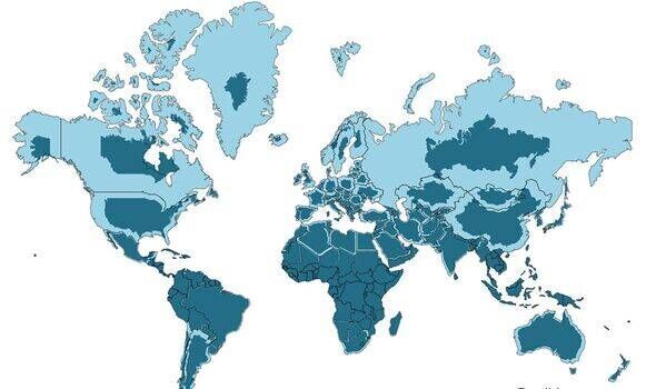
Understanding the true size of countries can often be misleading due to the way traditional maps represent them. A new interactive map effectively illustrates the actual size of every country in the world, challenging common perceptions that arise from standard map projections. Most well-known maps, including the Mercator projection, distort the size of countries, especially those near the poles. This can lead to significant misconceptions about the relative scale of nations.
For instance, countries like Greenland appear much larger than they are in reality, while nations closer to the equator, such as Africa, are often downplayed. The new map uses a different projection method that allows viewers to see the true proportions of countries, offering a more accurate perspective. This feature is particularly useful for educators and students who wish to grasp geographical concepts more effectively.
Furthermore, the map serves to highlight how geography plays a crucial role in the global economy, politics, and culture. By providing a clearer view of the land area occupied by each nation, it encourages discussions about resources, population density, and economic opportunities. For instance, while Canada is one of the largest countries by land area, its population is relatively small, which significantly influences its economic landscape.
This innovative mapping tool not only enriches our understanding of geography but also promotes awareness about global issues, including climate change and urbanization. As more people engage with this interactive resource, it is likely to spark conversations about international relations and global citizenship. Ultimately, understanding the true sizes of countries can foster a greater appreciation for the diverse world we inhabit.
Please consider supporting this site, it would mean a lot to us!
